Sea level change

Global sea level change for much of the last century has generally been estimated using tide gauge measurements collated over long periods of time to give a long-term average. More recently, altimeter measurements — in combination with accurately determined satellite orbits — have provided an improved measurement of global sea level change. To measure sea levels prior to instrumental measurements, scientists have dated coral reefs that grow near the surface of the ocean, coastal sediments, marine terraces, ooids in limestones, and nearshore archaeological remains. The predominant dating methods used are uranium series and radiocarbon, with cosmogenic radionuclides being sometimes used to date terraces that have experienced relative sea level fall.
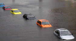
Flood at Bangladesh

Bangladesh has three great rivers the Brahmaputra, the Padma and the Meghna around 230 smaller rivers flow into these. As there are so many people living in the country, they have to use every bit of land available for farming, even the riverbanks. These riverbanks are prone to erosion and people frequently plunge into extreme poverty when they lose their land and homes due to erosion. Although floods are an annual event, huge floods seem to be becoming more frequent. In 2004, a deluge destroyed 80% of the country's crops, killed 747 people and left 30 million homeless or stranded. The floods of 2007 were not as severe but caused far greater health problems such as cholera and diarrhoea than has been seen for at least a decade. Temperature increase caused by climate change will mean that more snow will melt in the Himalayas each summer. This water will run into the rivers increasing the chances of flooding and river erosion. If the snow melts fully, it could lead to severe water shortage.
The country could also receive 14% more rainfall by 2028, meaning more land will be flooded. Many of those living in coastal areas will have to move inland where the population is already high. Increased sea levels mean that salt is getting into the soil, making fields near the coast useless for farming. The salt is also killing off mangrove forests that are a vital protection against cyclones, storms and tsunamis. Climate change could also increase the number and intensity of tropical storms in the area.
Predictions suggest that climate change could mean that by 2050, 15 million people may be made environmental refugees in Bangladesh. Comprehensive flood control and emergency measures must be taken immediately.
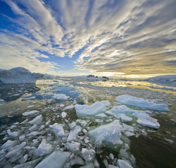
Dominance And Change In The Arctic

The Arctic region has long been considered international territory. Five countries—Canada, Denmark (via Greenland), Norway, Russia, and the United States—share a border with the frozen Arctic Ocean. Some of these nations have claimed parts of the region to be their territory.
Underlying the interests in the area are potentially vast oil, gas and other resources, as well as the opening up of lucrative passages for trade and economic activity as climate change reduces the amount of ice in the region. As a result, these nations have been vying for dominance in the Arctic.
Climate change provides an additional threat — not just to the local wildlife and indigenous populations that are already seeing their surroundings change rapidly, but to the rest of the planet, too. While retreating sea ice may open up shipping routes, the regions ability to reflect sunlight back into space would diminish, further increasing climate change effects.
This is your new blog post. Click here and start typing, or drag in elements from the top bar.
This is your new blog post. Click here and start typing, or drag in elements from the top bar.
Glaciers are considered among the most sensitive indicators of climate change. Their size is determined by a mass balance between snow input and melt output. As temperatures warm, glaciers retreat unless snow precipitation increases to make up for the additional melt; the converse is also true.
Glaciers grow and shrink due both to natural variability and external forcings. Variability in temperature, precipitation, and englacial and subglacial hydrology can strongly determine the evolution of a glacier in a particular season. Therefore, one must average over a decadal or longer time-scale and/or over a many individual glaciers to smooth out the local short-term variability and obtain a glacier history that is related to climate.
A world glacier inventory has been compiled since the 1970s, initially based mainly on aerial photographs and maps but now relying more on satellites. This compilation tracks more than 100,000 glaciers covering a total area of approximately 240,000 km2, and preliminary estimates indicate that the remaining ice cover is around 445,000 km2. The World Glacier Monitoring Service collects data annually on glacier retreat and glacier mass balance From this data, glaciers worldwide have been found to be shrinking significantly, with strong glacier retreats in the 1940s, stable or growing conditions during the 1920s and 1970s, and again retreating from the mid 1980s to present.[34]
The most significant climate processes since the middle to late Pliocene (approximately 3 million years ago) are the glacial and interglacial cycles. The present interglacial period (the Holocene) has lasted about 11,700 years. Shaped by orbital variations, responses such as the rise and fall of continental ice sheets and significant sea-level changes helped create the climate. Other changes, including Heinrich events, Dansgaard–Oeschger events and the Younger Dryas, however, illustrate how glacial variations may also influence climate without the orbital forcing.
Glaciers leave behind moraines that contain a wealth of material—including organic matter, quartz, and potassium that may be dated—recording the periods in which a glacier advanced and retreated. Similarly, by tephrochronological techniques, the lack of glacier cover can be identified by the presence of soil or volcanic tephra horizons whose date of deposit may also be ascertained.
Desertification of Nebraska Not Enough to Convince Climate Change Deniers, Says Poll
The tipping point that turns skeptics into believers seems nearly impossible to reach when it comes to climate change. That isn't changing anytime soon, according to the Shelton Group's new Green Living Pulse study. The poll surveyed 1,098 consumers who buy green products on occasion, and asked climate change skeptics what it would take for them to believe that climate change is real and caused by humans. Answer: even an ice-free North Pole or a dustbowl on the Great Plains barely move the needle.
The study says that 15% of skeptical respondents would be convinced by a melted polar ice cap, 15% would respond if kids should no longer go outside to play in the summer because of dangerous pollution levels, 3% would be swayed if changing weather patterns turned Nebraska into a desert, 2% would warm to the idea if there were only 20 polar bears left in the wild, and just 0.6% would be convinced if residents of America Samoa had to relocate because of rising tides.
Perhaps it's just hard to imagine future scenarios. The study also reveals that 55% of respondents have started thinking more about energy and the environment as a result of the West Virginia coal mine explosion and and the Deepwater Horizon disaster.
As those events show, it's hard to change people's minds about the environment unless something horrifying is actually occurring. Actual TV footage of dustbowl Nebraska is more powerful than trying to imagine how you'd feel about the same thing. If things get really bad, we might see the diehard SUV owners scrambling to buy tiny hybrids.
 RSS Feed